
Recomienda este artículo a tus amigos:
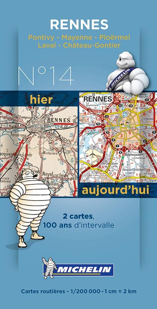
Michelin France Centenary Map 14: Rennes : Pontivy - Mayenne - Ploërmel, Laval - Château-Gontier
Michelin
Nuestros clientes opinan:

Michelin France Centenary Map 14: Rennes : Pontivy - Mayenne - Ploërmel, Laval - Château-Gontier
Michelin
New and historical map of Rennes in a smart plastic sleeve.
Commemorating the 100th anniversary of the 1st World War and celebrating 100 years of its mapping scale 1/200,000, Michelin proudly introduces a new historical map collection.
The Rennes centenary map includes a facsimile of early 20th century mapping and the same map from today, both scaled 1/200,000. This pack offers a unique view of what cities such as Rennes, Ponitivy, Mayenne, Ploermel, Laval and Chateaux Gontier looked like before the war and how they look like today.
colour mapping
| Medios de comunicación | Libros Print (Material impreso diverso) |
| Publicado | 14 de enero de 2014 |
| ISBN13 | 9782067192249 |
| Editores | Michelin |
| Genre | Maps & Guides |
| Dimensiones | 150 g (Peso (estimado)) |
| Lengua | French |
Mas por Michelin


Otros también han comprado
![Cover for Simon Ankjærgaard · Augustoprøret 1943 (Bound Book) [1.º edición] (2020)](https://imusic.b-cdn.net/images/item/original/379/9788711983379.jpg?simon-ankjaergaard-2020-augustoproeret-1943-bound-book&class=scaled&v=1599570193)
![Cover for Jakob Martin Strid · Den fantastiske bus (Bound Book) [1.º edición] (2023)](https://imusic.b-cdn.net/images/item/original/098/9788702152098.jpg?jakob-martin-strid-2023-den-fantastiske-bus-bound-book&class=scaled&v=1696053829)
![Cover for Tove Jansson · Billedhuggerens datter (Sewn Spine Book) [1.º edición] (2014)](https://imusic.b-cdn.net/images/item/original/561/9788702162561.jpg?tove-jansson-2014-billedhuggerens-datter-sewn-spine-book&class=scaled&v=1410942970)
![Cover for Herbjørg Wassmo · Dina-trilogien: Karnas arv (Sewn Spine Book) [7.º edición] [Paperback] (2015)](https://imusic.b-cdn.net/images/item/original/206/9788711326206.jpg?herbjoerg-wassmo-2015-dina-trilogien-karnas-arv-sewn-spine-book&class=scaled&v=1415700335)


![Cover for Camilla Biesbjerg Markussen · Skærekager deluxe (Bound Book) [1.º edición] (2021)](https://imusic.b-cdn.net/images/item/original/905/9788794086905.jpg?camilla-biesbjerg-markussen-2021-skaerekager-deluxe-bound-book&class=scaled&v=1631383695)
Ver todo de Michelin ( Ej. Map , Paperback Book , Book , Hardcover Book y Sewn Spine Book )